Wednesday, August 21, 2024

The Planets Aligned for a Most Perfect Day!

When I got home last night, I just checked Facebook for a moment before going to bed. Idae a few posts saying that Lael Wilcox would be coming through on her record setting ride around the world. The closest she would get to me was Rochester. She would be leaving from Elma sometime around 9:00 or 10:00am. Hmmm…could I get to Rochester before she did? We both had a similar distance to ride, but she is way faster. Perhaps if I left at 8:00, I would get to Rochester with plenty of time (especially if she left Elma closer to 10:00). 

Having just come off a four day bikepacking trip (see previous four posts), where I have been getting up early, it was no surprise that I was awake before 6:00. It’s amazing how quickly one can get ready when there’s no tent to take down. I was out the door by 7:20 (nothing like an extra cushion). I stopped briefly in Littlerock to check Lael’s tracker. She wasn’t moving yet. I had 8 miles to go to Rochester. 

I arrived just about 9:00. I went over to the IGA to use the restroom. When I came out, I checked the tracker again! She was on the move!

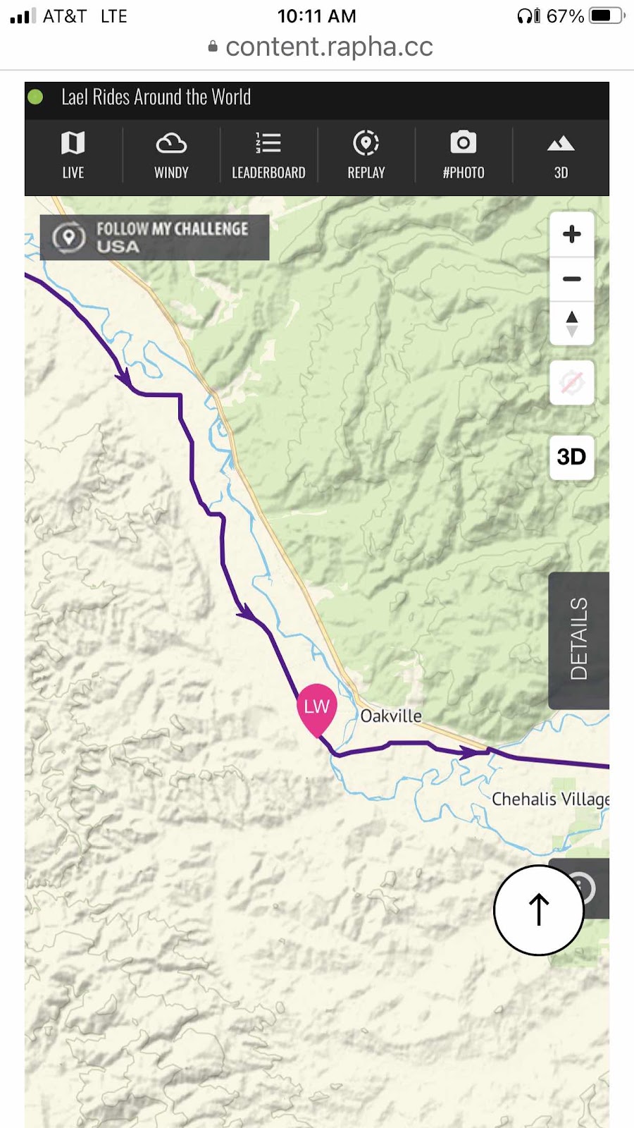
This was a bit later. 

I knew there was a crew waiting for her in Centralia. Chris Brewer saw I was in Rochester and asked me to keep him posted. I texted him when I saw her coming. Stephanie Earls and Sarah Brooks were also meeting up in Centralia. 


Here they come!!!

I was waiting on the corner of US 12 and Albany. They made the turn without even slowing down! I took off after them, and thanks to a guy named Matt who gave me a boost, I got on a wheel. 

Lael leading the way on the left (it’s against the rules for her to draft).

Once I could breath again, I moved up next to Lael and told her it was me, Colleen Welch! The shock and surprise on her face was great. See, I’ve known Lael since we did the Inaugural group start of the Baja Divide. The last time we saw each other was in La Paz, Mexico, where a bunch of us hung out at the hostel for a few days. 

We had a good chat catching up, then, as we were moving along at 18 mph, I finally had to drop back into the draft. Thankfully, it is flat to Centralia. We picked up a few more riders on our way into town, then, as we went by the Catholic Church, we picked up Chris, Steph, Sarah, and a few others (some had dropped off and turned around). Once again, we did not even slow down. Luckily to the new additions, we came to a red light, and everyone was together. 

I knew I would get dropped as soon as the first climb appeared (Centralia Alpha Rd), so I once again rode up to Lael to let her know I would be turning back before the climb. I introduced her to Chris (and told her Stephanie was my bikepacking adventure buddy), then took the opportunity to take this selfie. 

So so awesome to get to see Lael again, and in the midst of her setting a new world record!

Steph also turned around with me. We rode back into Centralia, and to Steph’s van. I could have ridden back to Oly with Steph, but I had made a train reservation for the 518 train north at 3:44. Steph said she was hungry, and it was almost noon. We went to Berry Fields Cafe (my favorite Centralia restaurant) and had some lunch. Then Steph headed home, and I headed to the train station. I went up to the ticket window to get the tag for my bike. The agent asks if I want it now, even though my train isn’t until later. I told him I wasn’t going to go anywhere, and commented that I had already missed the earlier train. Then he says, “Actually, that train hasn’t arrived yet. It’s late.” I asked if I could get on that train instead. He checked, and for $2.00 more, I could! So, instead of waiting until 3:44 (or whenever that train would arrive), I only had to wait 15 minutes! 20 minutes after boarding, I was back in Lacey! Home by about 2:45. 

Thanks for the ride, Amtrak!

What an amazing day! I’m so glad I got back on the bike (I know I would have kicked myself if I didn’t do it)! I look forward to continuing to follow Lael’s progress as she gets this new world record. If you are interested, she does a nightly podcast (yes, in addition to averaging 170 miles a day, she takes time to do a podcast), you can find it on Spotify. It’s called “Lael Rides Around the World”.


Day 4-Gunsight Ridge-Deciding to Finish Today, And a Bonus Adventure For Makaela

Last night was pretty chilly, but I was toasty warm in my quilt. I did add my hoody for a little more comfort. Woke up about 6:15. 

My campsite by the road. I didn’t bring my Ursack, so I just put my food bags back on Billy, and moved him further away. Nothing was disturbed. 

Makaela emerged from her hike back up from the lake at about 8:30. I had finished packing and was sitting in my chair in the sun. 

I had calculated it would be 20 miles to Knebel Springs CG where we had planned to stay. There would be some climbing, but a lot more downhill, then it would be almost entirely downhill back to The Dalles. It would be about 44 miles if we did the whole thing. We decided to give it a go. 

I couldn’t do the whole distance on the water I had. I wanted to stop at Fifteenmile CG and get water. It was on an out and back (about a mile in) that we weren’t planning to do. Makaela would get her water down at the lake. So we decided I would go ahead and get going. Makaela still had another trip back to the lake to get the rest of her stuff (and filter water). We would meet at the turnoff to Fifteenmile after I had gone to the campground and gotten water. 

There was still nearly a mile of yesterday’s climb to go. I managed to ride all of it, even though it was still pretty rocky. 

Jean Lake down below. 

Then there was an equally rocky descent before starting another long climb. There were some great views. 

Looking east. 

After awhile, I had to get off and push. It was too steep and big rocks…I just run out of steam. 

A nice clear view of Mt. Hood 

And Mt. Jefferson too!

For awhile it seemed like the mountain was moving with me (Makaela and I noticed this yesterday as well). Eventually, I seemed to get past it. 

As I was climbing, I came to a few creeks/waterfalls that were coming off the hillside. I had 1.3 miles to go on the climb. The out and back to Fifteenmile would be 2 miles (1 mile downhill and 1 mile back uphill). If I got water now, I wouldn’t have to do the extra two miles. I would only have to carry more water for .3 of the rest of the climb. I decided to do it. I also drank a bunch (“camel up” as they say).

When I got to the turn for Fifteenmile, I took a break, hoping Makaela would catch up to me. After awhile, she still hadn’t arrived, so I sent her a message via our inReaches. I also left her a note scratched out in the dirt…”NO NEED H2O WENT (then I drew an arrow) COLLEEN”. 

She got the message, saying maybe she would catch me at lunch. She usually seemed to like to eat lunch around 1:00 or 1:30, so I stopped at 12:45. Well, I waited and waited…for about an hour and a half. I texted Makaela to tell her I was moving on, assuming she had stopped someplace else for lunch. 

From my lunch spot it was mostly downhill with just a few more short climbs. Later, I got a cryptic message from Makaela saying she wouldn’t catch me, and she had had a “Bonus Adventure” That she would tell me about when she found me. 

I went past Knebel Springs CG (where we had planned to stay). I eventually made it to Skyline Rd. Now I was gradually moving out of the fir tree forest, and back into Ponderosa pine. 

Forest is changing!

Getting drier again. 

There was a lot of down with the occasional slight up. Soon I could see the Gorge and the Columbia River off in the distance. 


The top of the last climb. 

But still some rollers. 

The Columbia!

Maybe I’ll ride this right down to the river!

Down down down I came on Skyline. Finally hitting the pavement. 

The Dalles!

Still a lot of down to go. 

We had been over there somewhere four days ago. 

End of the gravel. 

The Dalles Dam, and still a lot of elevation to lose. 

I made it back to the car at 4:20. I got changed, and sent Makaela a message. She said she wasn’t far, but not sure how far. At about 5:00, she rolled in. 

Finished!

If we were to do this route again (or recommend it to others), we would make a couple of suggestions. Stay on FR 27. Don’t do the ridiculous singletrack/crappily graded section. Don’t do the singletrack after Little Badger Creek Trailhead. Stay on the gravel road that avoids it. Also, we didn’t do the Historic Barlow Rd section. To do it, allow for plenty of time as it is probably more difficult with a lot of elevation gain. Someone said not to underestimate Barlow Rd. 

And now, the part you’ve been waiting for…

Makaela’s Bonus Adventure

So, why, when Makaela is so much faster than me…why did she not catch me? Three reasons, but the first two don’t really count. As in, had only those two things happened, she would have likely caught up to me. First, what were those two things? Remember how Makaela had camped down at the lake? Well, she ended up not leaving until a little after 10:00 (I left about 8:50). So that was one thing. Then, the second thing that happened was she crashed. Fortunately, not too bad, a scrape on her arm, and general soreness (more bruises will show up, I’m sure). She says it was at a section that wasn’t too sketchy, but that whole part was not easy. No, neither of those things were the reason she didn’t catch up to me. It was the third thing that did it. She had her fanny pack attached to her sleeping quilt bag. At some point after she had started moving again after the crash, she noticed it was gone. Thinking it was back at the crash site, and she hadn’t gone that far, she left her bike, and started walking back. It wasn’t at the crash site. She continued walking, and walking, and walking some more. Finally, after almost getting back to where she had started the day, she found it laying in the middle of the road. Then she had to walk all the way back. She said it was about 6 miles! That was the clincher. That was why she would not catch up to me. 

She was smart as she came back into town to not do the final short, but steep climb, plus a few rollers, and instead came back in similar to how we had gone out of town. Curiously, we still had the same mileage. So, in the end, it all worked out, and she survived her bonus adventure. 


Day 3-Gunsight Ridge-Outsmarting the Route, but Still a Long Day

I slept pretty good last night. It was nice with the sound of the creek, and not hot. Thanks to that fine line of dehydration, I only got up once. 

I woke up at 5:45 for good. Warmed up my clothes in my quilt before starting the morning pack up process. Makaela was still silent. Got my stuff packed inside my tent, did a good session of stretching (back was a little stiff after all the pushing yesterday), and continued getting ready. Makaela was still sleeping after I had finished my breakfast. I wish I could lay in my tent that long, but my back says otherwise.

Because I’m a much slower climber than Makaela, I headed out at 8:20. There was a pretty good climb right out of the gate. Had we continued yesterday, I would have been walking. 

I made it out to the pavement. 

Nice downhill!

I got to Rock Creek Campground after 5.7 miles (longer than we thought). There I got water and waited for Makaela. She was about 30 minutes behind me. She had texted me to go on, but I didn’t have service. I did start out while she was getting water. 

The route turned off Wamic Rd onto gravel. This was the connection to the Historic Barlow Rd. Only the route had us going up a stupid way. We did figure out that we could use a different gravel road to connect to Barlow Rd, but we also knew we could just stay on Wamic Rd and skip Barlow altogether. Because we were a bit behind in miles, and because we were a little tired of sketchy routing (remember yesterday’s debacle?), we decided to stay on Wamic Rd. It would take us all the way to Hwy 35 a couple miles before Bennett Pass. 

Now, you might be thinking we were cheating on the climbing. You would be wrong. We still had to climb for the better part of 15 miles. There were a couple of descents, but then it would go right back up. The only difference was that it was paved. 

We also saw this wildlife. 

From a distance, I thought it might be a bear. But, since Makaela kept on riding, I thought it might be a rock. It wasn’t. 

See the thing around it’s neck? It must be a gps tracking. 

Finally we came around the corner and got this view of Mt. Hood. 

Not too much further to Hwy 35. 

Once we got on the Hwy, and made it to Bennett Pass, we turned into a Sno-Park to then get back on the gravel. 

Mt. Hood from the Sno-Park. 

Back to gravel, and continuing to climb. 

Pano at a viewpoint. 

Mt. Hood with the clouds moving out. 

At the viewpoint, there were tons of huckleberries. 

We spent a fair amount of time filling our mouths with berries. 


The climb continued. I was out of steam, and had to push up the steep parts. It didn’t help that it was very rough and rocky. 

Too steep for me to ride. 

Might that be the top up there? Yes, but only a brief down, then back to climbing. 

Interesting rock formation. 

We came to this intersection. Guess which way the route went? Yep, uphill! Back to pushing. 

About 1 1/2 long miles later, we finally reached our destination. It was a trailhead down to Jean Lake. We hadn’t originally planned to stop here, but not doing Barlow made it so we got here. We still did 38.9 miles (and almost 5500 feet of elevation. 

Bikes are not allowed at Jean Lake because it is a wilderness area. The problem is the lake is a third of a mile hike down. Camping at the lake meant we would have to carry all our gear down to the lake. It would take multiple trips. I decided I didn’t have the energy left for more than one trip down and back. There is a somewhat flattish wide spot on the road. I decided to camp here. Makaela decided to go down to the lake. She made two trips. I took my water filter down to get enough water for tonight and tomorrow. 

The trail. 

Jean Lake. It is pretty, but not enough so to make me want to carry all my stuff down there, then back up tomorrow morning. Makaela and I said our goodnights as she was heading back down, and I was going back up. 

It was 8:00 by the time I was eating dinner. Now I’m in my tent, and it’s time to go to sleep. At least we don’t have as far to go tomorrow. 


Tuesday, August 20, 2024

Day 2-Gunsight Ridge-Finally in the Forest

Remember when I said I was in my tent because of the thunderstorm last night? Oh my, it was epic! There were at least two storms that rolled through. The thunder and lightning went on and on. This morning our tents were covered with detritus from the trees, and mud from the splashing rain drops. So, needless to say, even though we got up pretty early, it took us awhile to get rolling. Still, we were on the road by 8:40.

Nice morning view of Mt. Hood. 

We started out the day on the same course as last year’s Gorge Gravel Grinder. It deviated a bit, but would come back to the course again. One part that was kind of funny was that we did a portion of the “Chicken Out” route (it was an option to avoid a rougher part…we had done the rougher part in the race).

We made it to Friend. There is the old schoolhouse, which is now also the Community Center. Inside there’s a chalkboard that people sign, or leave messages. 

Here we also met Adam, Jason, and Vinnie. They were out for three days, doing a similar route, but started in Maupin. 

Inside the schoolhouse. 

Me adding an egg and a chicken. Why? Because we had met a guy named Terry who has chickens (gets about 170 eggs a day). He’s the one who told us we had to sign the chalkboard. 

See the egg and chicken?

Info about the school. There’s not much a town there anymore. Just a few houses. 

Our next turn was finally onto Forest Road 27. All the other roads had been country roads or farm roads. Finally we were getting into the Forest. The road was actually paved. 

The Forest. 

We stopped for some lunch. Afterwards, we continued climbing on FR27. Shortly after restarting, my Garmin said we were off course. I yelled for Makaela. She came back, and we went back to where we were supposed to turn. First, we looked at the route, and saw that we could stay on 27 as we would be coming back to it. But, we foolishly decided to stick to the route. It was a sort of decommissioned road that often looked more like singletrack. Then we got to a part that had been roughly graded (and by “roughly”, I mean terrible).

More singletrack than road. 

Makaela doing her trail maintenance duty. 

The terrible job of grading. 

And then we had to cross this creek (Tigh Creek), and you can’t really tell, but the bank on this side to get back up was very steep. Makaela and both had to push Billy up. 

We were both getting really tired of the track, especially because we could have avoided it. Oh well, we survived. We came back out to 27, and shortly after, met up with the guys again. They were not on hardtails, and had wisely stayed on the paved road. 

Next up was another section that we could have skipped. But no, we followed the guys down to Little Badger Campground, where they stopped for a snack, and we continued on to more singletrack. This time we had to push the bikes back up from the creek. That was not pleasant. The trail was called North South Road Trail. We finally finished the steep climbing. Then the route turned, but there was no road or trail. Looking closer at the route on our phones, Makaela noticed there was just a little loop that would come back to what we were “supposed” to be on. When we came back to the route, it still looked better to stay on the NS Rd Trail. We decided to skip the part of the route and stay on the Trail. It looked to be more of a straight shot, and a better trail (fool us once, shame on you…fool us twice, shame on us…fool us a third time? NO!).

It was still not easy, and I still had to push for a lot of it. 

Steeper than it looks. Plus, I was really running out of steam. 

Once we were back to gravel, we came down to Badger Creek (the big one). Makaela was thinking maybe we could camp there. But, one, it was a trailhead, and two, if we stopped 5 miles short, then we would have to add those to tomorrow, when we already have 34.5 and a lot of climbing. We decided to continue on. We crossed the creek, and started up another climb. A few yards up the climb, we came to Bonney Crossing Campground. We looked longingly at the campground…and decided we didn’t care about how much we had to do tomorrow, we were done!

Home for the night!

The view of the creek from our campsite. 

It was 4:15. We did 30 miles and 3488 feet of elevation. Similar to yesterday, but a lot slower due to all the hike-a-bike. Tomorrow, if the route looks sketchy, we’ll evaluate more carefully…maybe.