As I was leaving the most bike friendly city, Portland, I had no trouble finding my way to the St. John's Bridge. I just had to follow the signs.

I made it over the bridge. The St. John's Bridge is one of the prettiest of Portland's many bridges--very gothic looking. Don't know if you can see the "sharrows" on the far right lane, but they are there and I was able to ride comfortably.

I came down on the other side to Hwy 30. At this point I was basically doing the reverse of the STP route from last year. However, I was only on Hwy 30 for a couple of miles before I took a left on Newberry. See the hills in the background of the bridge photo? Yeah, I had to get over them. Newberry was pretty much a steep 2 mile climb up to the top.  If street names are any indication of how high up I was, the road I turned onto at the top was called Skyline. Coming down I was on Old Cornelius Pass Rd. Since I only came down on Old Cornelius, I figure Newberry must have been the up side of the Pass. Maybe I can add that to my list of Passes I will do on this trip.
I didn't have a map for this route. I was following directions from the "Bike There" app. So far, everything was as the app directions had said. However, at one point the directions had me turning onto a gravel road. Since I have this new-found fondness for riding on gravel roads, I continued to follow the directions. It ended up being just a 1/2 mile section of gravel before I turned onto another paved road. Still looking good!
I rode past some huge blueberry fields! They are not quite ripe yet, but give them a couple of good hot days...
After several more turns and another short gravel section, I reached the Banks-Vernonia Trail--my purpose for going this direction to the Coast.

Back on the trail I came to this beautiful green mossy section. Had to take a photo!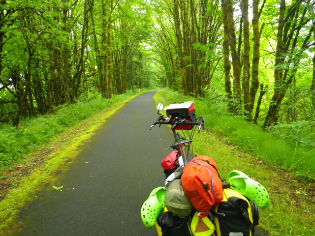
Then I came to a long trestle. This trail is also for horses, but they only let bikes and pedestrians on the trestle. Horses have to go down and around.

Just after the trestle, there was a road called Bacone. According to my Bike There directions, I was supposed to exit the trail and go onto this road to get to Vernonia State Park. It just didn't seem quite right. I pulled out my phone for a little Google Maps assistance and saw that there was no Vernonia State Park showing up on Bacone Rd. I opted to stay on the trail as there was a Hike-In campsite further up the trail. I also saw a sign for a campground called Dairy Creek. It is part of LL "Stub" Stewart State Park (which you can't get to by going on Bacone Rd).
I decided to go to Dairy Creek because I figured they would have water and showers (right about the water, wrong about the showers). So I rode until I came to the sign pointing to Dairy Creek. Well, it was a 1/4 mile gravel trail that went up quite steeply! I got off and pushed Betsy (not an easy task when fully loaded). I had to keep going, because if I had stopped, I don't think I couldn't have gotten Betsy going again. I finally reached a section where I could ride, but it didn't last long before I was back to pushing. I reached the top, only to realize I could have taken a road! I'll be taking the ROAD down in the morning!
I rode around the park to check it out (the walk-in tent sites are at the beginning), hoping for showers. I found the pay station. I'm not paying because they want $21 for a walk-in tent site! And, no showers! I think that is a little exorbitant! When I returned to the walk-in sites, I chose one that is not as visible from the road. Although, it's not like I'm hiding. I'm pretty much in plain site, but there is a guy next to me who has set up a veritable Taj Mahal of campsites. He has so much stuff that when you look from the road in the direction of where I am camped, all you see is his stuff. I think it's brilliant! I'm planning to be out of here early in the morning anyway.
It's only 7:45, but I think I'm going to hit the restroom once more and retire to my tent. I didn't get as much sleep last night as SOMEONE kept trying to join me in my bed on the couch!
On to Fort Stevens tomorrow--about 70 miles. I hope not quite as many hills as today...
No comments:
Post a Comment