The first seven miles, according to the map, were on a wide, potentially dusty road. There were no issues with dust, but there was a road grader scraping the shoulder. I caught up to him only because the climbing wasn't too bad. Although I saw him once in my rear view mirror, I managed to stay ahead of him.
At about 12 miles (according to my computer which, as we know is not accurate), the map said to turn right onto FR 4134 up the South Fork of Poorman Creek. There was the option to continue on the main road over Stemple Pass, then rejoin the route near the Divide crossing. I maybe should have gone that way...but no, I went with the guys the way the map said. In addition to the directions to turn right onto FR 4134, it also had this to say..."Next 4.4 miles are extremely steep uphill, but they lead through fascinating (emphasis is mine) country with several stream crossings." Oooo, I thought, should be some good photo ops!
Here's Derik contemplating the fascinating country we would be riding through (the road we took is behind him).
After doing a few bike mechanic stuff (lubing chains, adjusting my saddle--trying to get rid of the numb hands, inflating my rear tire), we headed up the road to see what fascinating country awaited us. The first bit was horribly steep, but didn't last. I thought to myself, okay, that wasn't fun, but doable. The route flattened some. After awhile, I started seeing some of the fascinating country the map must have been talking about.
Fascinating, right?
Piles of dead wood...fascinating!
Okay, so not terribly fascinating. Then the climbing really started. Oh, we'd been going up (of course the guys were way ahead by now), but it wasn't anything I couldn't handle...at first. Then, although the steepness wasn't too bad, the length of the steepness became an issue.
It just kept going!
I ran out of power about half way up. I couldn't just stop and take a break because I couldn't get started again. So...I walked, and pulled MC up the hill. 20 steps...take a break...rest my arms...keep going...up to that...sort of...but not really...flat spot...
I was finally able to get back on and ride...until the next looooonnnnngggg, steeeeeep, hill. Crap, off and trudging again! 20 steps...take a break...you know the rest. How much more of this??? My arms were killing me!
Finally, I came around the corner, actually riding, and I could see the guys. Unfortunately, the road also decided to throw one more bit of steepness at me. By this time, I had had it, when I couldn't muster anymore energy, I stopped, started walking, then just laid MC down, took off my helmet, and said, through tears, "I'M DONE!" I left MC there. Connor came down and pushed her up the rest of the way. When I managed to walk to the top, Derik said he'd never seen me so upset. Was there a joke he could tell me? There was a pickup parked at the top. I asked why didn't they send the truck to get me?
Anyway, I recovered, ate some lunch, and then we went just a bit further (only one more short steep bit that I rode up) before reaching the actual crossing of the Divide.
Here's Connor taking a photo of the Continental Divide Trail marker.
The ride down was wild and rocky. It was also quite scenic.
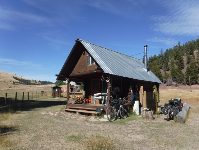
Our destination was a cabin provided for cyclists only. Connor went by it, but I kind of knew what I was looking for from another cyclist's video. If you are reading this, Russ, thanks for doing that video!
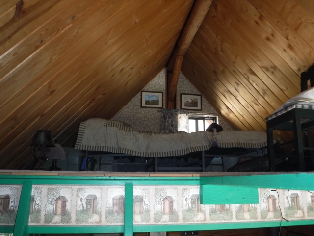
Well, this is quite the full service oasis! The cabin is owned by a couple that live in the house across the field. They started offering the cabin to cyclists about 4 years ago. It really is amazing! Check out the photos.
Upstairs
The other bed across the catwalk.
Outhouse
Complete with antique toilet seat!
And there's llamas in the field!
John came down to tell us anything we needed to know, and even gave Connor a couple of Mtn Dew. Derik's had wine, and we're having pancakes for breakfast!!!
So, a tough day, but a great ending!


No comments:
Post a Comment