Wednesday, September 25, 2013

Rainbows-6, Wildlife-0

LDay 3--Glacier National Park

Today was the day, time for the Going to the Sun Road! We packed up and got on the road. We made the turn toward West Glacier and Going to the Sun Road. What do we see ahead? A sign that says, "Road Closed 33 miles ahead--Logan Pass". WHAT??? We continue past the Glacier Park sign to the Entrance Station.

Sure enough, as of last night, the Going to the Sun Road is closed at Logan Pass. Dang! That means we go up to the Pass, then have to come back down and go around Glacier to the other side. That makes for another 2 1/2 hours of driving. All we can do is roll with it. Besides, we have all day...

We make a brief stop at the Apgar Visitor Center and get a map. The Ranger highlights our route telling us where we will likely see wildlife and whatnot.

Driving on the Going to the Sun Road, we near McDonald Lake Lodge (where we originally planned to stay) just as three of the "Red Bus" Tour busses pull out. We decide to follow them, figuring they know the most scenic places to stop. 

The busses first turn to cross a bridge at the end of McDonald Lake. We followed and got a great photo of the lake.

We continued to follow the busses for awhile, but then ended up pulling off to take photos. It was raining, but the scenery was still spectacular. Here's a photo.

We continued driving up and up, pulling out frequently to take photos. The higher we got, the more the rain turned to sleet. Finally we reached the top of Logan Pass. As an aside, although the climb is long, it is pretty much a steady 6% grade. Doable on the bike. 

It was very foggy and sleeting quite heavily at the top. The red busses were there. Kim and I got out, but it was pretty darn cold (on a bike it would have been miserable). I walked up to the closed Visitor Center, took a photo and slid my way back down.


Pretty darn cold!

We went back the way we had come. Down, down, down. 


We stopped a few times coming down. Back to McDonald Creek, we stopped and Kim and I walked to a lookout.


We returned to Hwy 2 and started our "Detour" to get to Babb. We crossed the Continental Divide again at Marias Pass. There was definately a change in the landscape.
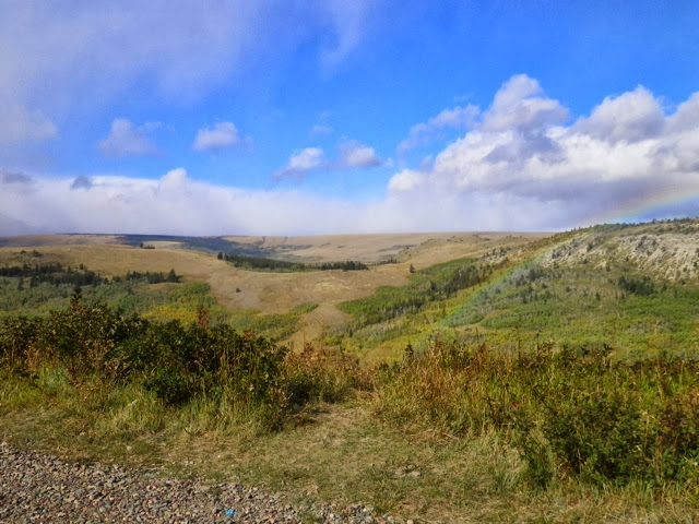
Notice the faint rainbow. This was just one of 6 rainbows we saw today (what that really tells you is that it rained most of the day).

When we reached the turn to go to Montana's Duck Lake Lodge, we decided to go on into Babb and go up to Many Glacier. The Ranger said it was a good place to see some wildlife. Up to now, we had not seen a single wild animal--not even at the top of Logan Pass (where there are supposed to be tons of Big Horn Sheep--maybe they didn't care for the nasty weather???).

Shortly after turning on the road to Many Glacier, we saw a grouse on the side of the road. Unfortunately, we didn't get a photo. We did get some nice mountain photos along the way.


We drove back to Babb. Montana's Duck Lake Lodge is like a hostel. We have three twin beds in our room. The sink room is across the hall, the shower room is next to that, and the toilet room is the next one over. I'm sure this is the first time my dad has stayed in this type of establishment.

We did find some wildlife finally.

Hopefully, tomorrow, the sheep will decide to come to the party.


Sunday, September 22, 2013

Two States, Two Falls, and a Swinging Bridge

Day 2--The Moore's to Columbia Falls, Montana

We left the Moore's after a leisurely breakfast. We thought we might have left Dad's phone, but we found it (perhaps we have a heightened sensitivity to leaving things behind). We set "Tammy" (the Tom Tom) for Columbia Falls, MT. We planned to take Hwy 2 per John's suggestion. When we got to Hwy 2, Tammy told us to turn right. We did, then we were told to turn left. At the next direction (turn right), I realized Tammy was taking us to I-90. In addition to that, the road was closed. We turned around and went back to Hwy 2. Tammy kept trying to tell us to turn around. Finally she gave up and recalculated the route. 

We crossed into Idaho at Priest River.

We followed Hwy 2 across the panhandle of Idaho. Before coming into Libby, we came to the Kootenai River Park Lookout and Swinging Bridge. We're not sure, because there was no "Welcome to Montana" sign, but we think we were in Montana.

We pulled over, and Kim and I (Dad stayed in the car) walked the trail to the lookout (over the train tracks on the bridge), then onto the Swinging Bridge. It was, supposedly, .24 miles to the bridge. It seemed longer. The views of the Kootenai River and falls were very cool.
The bridge over the train tacks.

The Falls

Kim and I at the Falls

The River

The Swinging Bridge


On the Swinging Bridge 

Walking back, we heard a train coming. I ran back to the train bridge. I caught just the tail end of the train as I got to the bridge. Unfortunately, my camera was set on video...

We continued on toward Columbia Falls. From Kalispell, we had just a few more miles to get to Columbia Falls. 

We are just outside Glacier National Park in Columbia Falls. Tomorrow we travel the Going to the Sun Rd!


Third Time's a Charm

Day 1 on the road was a few hours more than anticipated.

We got everything packed, including sandwiches for lunch, and were on the road by 9:45. We headed up the Columbia Gorge Scenic Byway in cloudy, but dry weather. Since Kim hadn't been through the Gorge, we took a short detour through Mosier up to Rowena Crest.
Dad and Kim at the Crest

We came down through the Rowena Loops, and got back on I-84 continuing East.

We passed through The Dalles, past Rufus, and Biggs Junction. Not too far past Biggs, Dad hollers out, "Oh Damn! I forgot my Passport!" As we are now on a stretch of road with no exit, we spent the time trying to think of a way to get his Passport. As we come to the Phillippi Canyon exit, we realized we would just have to go back to Vancouver and get it. So, I turned around and back we went. We'd been on the road for about two hours. I texted Annette telling her we would be about 4 hours later than we anticipated. 

We rolled back into Vancouver at about 2:15, stopped and refilled the gas tank (at the same gas station we had stopped at on the way out of town), and went back to the house. We decided to just go ahead and eat our lunch at the house (so, basically, we took the sandwiches for a 260 mile ride). By about 3:00 we were back on the road (Passport firmly in shirt pocket--checked and double-checked). The weather had changed from relatively nice, to rain, but once we got further up the Gorge (for the third time) the rain stopped. We even saw a rainbow.

We made pretty good time as I was pushing the speed limit just a bit. We made it past the turn around point, on through Boardman to the turnoff to Umatilla and Hermiston. From there we turned north through Kennewick and Pasco. From the second time we left Vancouver, we did not stop until we were not too far out of Spokane at the last rest stop. There, we pulled off for a quick potty break.

We pulled into Annette and John's place about 8:45, tired and hungry (as Kim said, those sandwiches were long gone!). John and Annette had a delicious dinner of lasagna, garlic bread, and watermelon waiting. After some visiting, we all hit the sack!

Tomorrow shouldn't be so long. The Passport is already in the car.

Thanks John and Annette for hosting us!


Sunday, September 15, 2013

What I Will Do for a Milkshake!

What was I thinking? 9310 feet of elevation gain in 68.2 miles for a milkshake??? Yep, that was today's ride--The 2013 Milkshake Challenge. 

What is the Milkshake Challenge? It is an unsupported OOA/CBC bike ride put together by one of our OOA Team members. It's just for fun (fun, being a relative term). It is also a contest of sorts which I will explain later.

Climb #1

The ride started at the Sno-Park parking lot at the base of Crystal Mountain Blvd. on the way to Mt. Rainier.
There were around 18 of us (7 women!). The first climb of the day was up to Crystal Mountain Ski Resort. We all started with arm warmers as, although the sun had come out, it was still pretty chilly in the shade. In short order, however, all arm warmers had become wrist warmers. It was a 6 mile climb that started right out of the parking lot. No time for warming up! I managed to stay close to the gals on this one. At the top of Crystal, we took a team photo and a women's photo.


Then we got to ride back down! It was a little chilly, but it felt good after the climb.

Climb #2

After regrouping back at the start of the first climb, we headed out for Sunrise. That meant heading into Mt. Rainier National Park.

We turned off Hwy 410 to White River and Sunrise. After a brief downhill, we came to the entrance station. We each paid our $5 entrance fee and started the long climb. It was somewhere around 12 miles of solid climbing. I stayed up with the gals for awhile, but then could no longer go their pace. Part of the reason is that I have one more easier gear than most of them. That means that, although I can pedal easier, I go slower. Now, I could just not use that gear...yeah, that's not gonna happen!

As I reached the higher elevation, I had the same problem I had on my last tour. I started to get a sinus headache. After awhile I took more sinus medication (with acetaminophen). It didn't really make it better, but it didn't get much worse--which was good as I still had probably another 1500 ft to go. As I continued up, I could see Maria up ahead. She was off her bike stretching her cramping calves (this was not an easy climb). She got back on just before I caught up to her, and we rode on together. As we reached Sunrise Point, I thought we were at the top but, no. We had another 300 ft of climbing to do. At least it wasn't as steep. We caught up to Lauren and Michelle. Michelle was having her own issues of needing electrolytes (if Michelle was having issues, this was for sure not easy). Lauren had her covered and Maria and I continued to the top. The rest of the group was waiting--eating and resting. At 6400 ft, Sunrise is the highest paved road in Washington.
Maria and the mountain.

Jim, Steve, and Dave

Yep, 6400 ft!

Mt. Rainier in all her glory!

After another group photo (some had left), we began the most awesome descent.


I passed a few people on the downhill (weight always wins going down). We exited the entrance station and returned to Hwy 410.

Climb #3

For the final climb of the day, we took a right onto Hwy 410 and started the 7 or so mile climb to Cayuse and Chinook Passes. Maria, Michelle, and Lauren opted to head back to the cars instead of doing Chinook (good idea). Jean was a climbing machine, so that meant I was on my own for this entire climb. At one point I just had to stop and take a photo of the mountain from this angle.
Such a beautiful day!

When I reached Cayuse, I took a brief little break before continuing the 4 more miles to the top of Chinook Pass. With about 3/4 of a mile to go, the group passed me coming down. It was very hard to not turn around and go with them, but I wanted to do the Challenge. So, here's what the Challenge was: From the top of Chinook, it was a coasting contest back to the cars. The person who could make it the furthest without pedaling would get a free milkshake from Dave.

So, I completed the ride to the top and even took this photo as proof before starting my coasting.

This was an even better descent than from Sunrise because the road was much smoother. I braked a bit in the hairpin turns, but mostly let Tessa fly. I even passed a car on a straight stretch. I was able to take the lane as I was easily doing the speed limit. There were a couple of slight rises, but I made it up them still going 20 mph (I think my max speed was 41mph). Toward the bottom with about three miles to go to the cars, the road went up a little more. I was still coasting, but by the time I got to the top of that rise, I was at 7mph. Still, I managed to make it to the next downhill without pedaling. In fact, I made it back and into the gravel parking lot before I had to put my foot down. 

So, who won? Initially, it was Mark who made it the furthest into the parking lot but then, Adam became the "official" winner because he just kept coasting past the turn to the parking for an additional 1 1/2 miles! I don't think I would have wanted to go the extra distance myself.

We all met at Wally's Drive-In in Buckley for the award presentation.

Congrats Adam!

Of course, I also had a milkshake. I just had to pay for it myself.

This ride was one of the more difficult rides I've done, but it was great to prove to myself I could do it. Also, the scenery was outstanding! I wouldn't necessarily recommend this ride to just anyone, but, if you've got the legs and the desire, it's a worthwhile challenge! And don't forget to reward yourself with a milkshake at Wally's (FYI--the burgers are pretty good too)!


Sunday, September 8, 2013

RSS-All the Regular Routes Done in One Day

RSS, Ride South Sound. It's a fundraising ride for the Capitol Bike Club--our local club in Olympia. Jean and I set out to do the 100 mile course. We met at the ride start, both riding from home, at the Harbor House on Percival Landing. We got our wristbands and cue sheets and left at 8:00. It was cool and foggy.

Boston Harbor

Our first destination was Boston Harbor. We've done Team rides, night rides, and even raced this route. Needless to say, we've done this one many times. But, on none of those times have we been fed at a rest stop at Boston Harbor Marina just 12 miles into the ride! 
Jean and others getting some snacks.
The Marina in the morning.

Johnson Point

Continuing on our usual Boston Harbor route, we worked our way over to the Chehalis Western Trail at Woodard Bay. We took the trail to South Bay Rd., where we turned for our second previously-done route, Johnson Point. Rest Stop #2 was about another 12 miles from the first one, at a fire station on Johnson Point Rd. They even had chocolate milk on this one! We don't get that on the regular rides! The sun was out by this time, so the arm and leg warmers came off, and the clear lens was swapped out for the sunglass lens. We continued from the fire station out to the end of the point and did the loop before heading back. 

We retraced our route back to town, with a little detour over to Rest Stop #3 at San Francisco Street Bakery. We'd been given $2.00 off coupons to use at the bakery (the rest stop had fruit and stuff too). Jean and I each got a chocolate covered coconut macaroon. Now, that was delicious!

Steamboat Island

After coming almost back to the start, we rode through town and over the 4th Ave bridge. We stopped briefly on the bridge to see if we could see Jean's Ron out kayaking. We saw kayakers, but none were Ron.

We did a common route through the neighborhoods of the Westside to come out on Harrison at the top of Mud Bay Hill. We continued down the hill to Madrona Beach Rd, and out to Steamboat Island Rd. At the Griffin Fire Station was Rest Stop #4. Luke from Joy Ride Bikes was working as the mechanic at that stop. We ate some fruit, and then continued on our way out to Steamboat Island. We made the lovely little loop around the island and headed back.
Jean crossing the bridge from the island back to the mainland. That's Totten Inlet in the background.

Instead of coming back the same way we went out, we took Young's Rd and Gravelly Beach Rd. Both are very roller coaster hilly, with a couple of longer climbs. Most of the downhills were steep enough to allow for an easy ride up the next one.

Rest Stop #5 was back at the Griffin Fire Station. We didn't really eat anything, but I did fill my water bottle. 

Delphi and Waddell Creek

So, we did all the "Points". The only direction left to go was south. From Steamboat Island, we headed back to town. At Mud Bay we turned and rode over to Delphi on McKenzie Rd. We've done Delphi this direction several times (even once at night), but we much prefer the other direction, due to the steady uphill climbs going south. We took Delphi to Waddell Creek--also not the preferred direction, up to Capitol Forest. We were close to 90 miles into the ride. At least it would be the last major hill. We stopped prior to the climb and ate a gel and Shot Blocks (we were both feeling the not eating at the previous rest stop). Coming down Waddell on the other side, Jean had a flat. I had no qualms with taking a break to fix the flat. 

Having not seen another cyclist since the beginning of Waddell, we figured not too many were doing the 100 mile course. We got to the 6th and final rest stop in Littlerock and asked how many had come through before us. They said just a couple--as we suspected. 

The final 12 miles or so back to town weren't too bad, but we were definitely ready to get off the bikes!
We rolled back to the Harbor House at 3:45. Ron was waiting and took photos of us finishing. The finish dinner was soup. We thought it was a somewhat strange dinner to finish with, but it was pretty tasty anyway. We just would have liked something of more substance. There was also bread, and that was good. They had extra loaves of San Francisco Street Bakery bread that they were giving away. I picked up a loaf that fit into my jersey pocket just right (I'll post the photo Ron took on Facebook when he sends it to me)!
All done (except for the ride home)!


After a good break, I got back on the bike for the 8.8 mile ride back home. 

Total miles: 117.6
Average speed: 15.6
Elevation gain: 4183 ft.
Total roads I have never been on before: 0


Monday, September 2, 2013

A New Sly-Dog Route

Day 3 in a row of higher mileage rides. Have almost ridden 200 miles in this Labor Day weekend.

Fortunately for me, the team ride of yesterday, which I did not partake (instead did a 54 miler with my friend, Julie, who was riding her new bike!), was another hill-climbing fest. Why is that good for me? Because the guys that rode yesterday were all tired for today's ride! That means one thing--I can keep up!

We headed out toward the southeast section of the county, in the area of Lake Lawrence and Smith Prairie. There are some great roads out there without too much traffic. To get there, we even went on at least one road I've never been on!

We worked our way along various roads and even made a stop at a gas station/mini-mart to eat and refill bottles (I've only experienced that on the club rides--never a Team ride)! Refreshed, we kinda sorta started heading back. It was a somewhat convoluted route, but I was doing fine, so I didn't care.

We had returned to Rainier Rd and taken a right. I thought they would turn left on Steadman, but then I heard them say they would turn right on Spurgeon Creek. I could have continued on Rainier to home, but I assumed they would ride Spurgeon Creek, maybe do Sun Lakes, continue on Spurgeon to Yelm Hwy, and Yelm Hwy back, where I would turn off at my neighborhood. Well, you know what happens when you assume...

We did, indeed, turn on Spurgeon Creek, and also did the Sun Lakes loop. However, instead of returning to Spugeon Creek Rd, while in the Sun Lakes neighborhood, we turned onto a road called Dawn Hills Dr. As we turned, I said, "Okay...we're going this way." I didn't exactly know where "this way" went to. One of the guys, hearing me, said, "We'll eventually get home." We came to a cul-de-sac. We continued straight through the cul-de-sac on what, to me, appeared to be a driveway. But, then I noticed it did have a name--Trowbridge St. Hmmm....I thought. Why does that sound familiar? One of the guys told me it came out at Rainier Rd just down from Fir Tree Rd. Oh, that's why it seemed familiar. I've seen Trowbridge many times from Rainier Rd. I just had no idea it connected to Sun Lakes. Well, it really only connects if you are on a bike (or walking). There are two gates separating the two neighborhoods (probably keeps the fire insurance lower for the homeowners having the alternate outlet). They were like a secret door! 

Once on Rainier, I did continue straight on home while the rest of the group turned onto Fir Tree. I ended up riding another 73 miles with an average of 18mph.

Just when I think I know all the secret, sly dog routes...I learn a new one! Yay!

Saturday, August 31, 2013

Riding the D-Line

Today was another 70+ mile ride with the Team. Fortunately, Maria rode too. Otherwise there would have been a lot of solo riding on my part.

Once again, Bill and Melody called the route. We were going to ride to Littlerock, up to Mima Rd, then to Bordeaux, and over to Oakville. Initially, they wanted to continue south to Garrard Creek, then back in on Independence Valley. However, most of the group felt that was a little too long, so a shorter route (for those who wanted it) was proposed. Basically, it just cut out the Garrard Creek and Independence Valley parts. Maria and I thought the shorter route would be just fine. 

I was happy with the route because I have been wanting to go over Bordeaux to Oakville for a long time. Awhile ago, I rode Stella up Bordeaux thinking I would end up in Oakville. Instead, I ended up at the Cedar Creek Correctional Facility. Bordeaux dead-ended there. Turns out there is this road off Bordeaux called the D-Line. The D-Line comes out just west of Oakville. 

So, we're riding along at a blistering pace (27-30mph--I'm barely hanging on) on Mima-Gate Rd. We get to Bordeaux, but we don't turn. What? I heard Mark say, "What happened to Bordeaux?". All I heard was something about the wind...that's the thing about bike rides--they are very "fluid" and can change at any time. I didn't really have time to be disappointed--I was working too hard to stay on the wheel in front of me!

Just when I couldn't stay with them any longer, one of the guys passed me and said Maria had dropped off the back. Ahhh...perfect! Now I can slow down and wait for Maria (she was without her flat repair kit, so I didn't want to leaver her behind). She caught up and the two of us continued at a much more doable pace. When we saw that the group did not turn onto School Land Rd, I figured what they were doing was riding the opposite direction of the route. Yippee, we would still get to do the D-Line!

At US 12, we caught up to the group (they had to wait for a bunch of traffic--good for us!). They took it easy for a short while which allowed Maria and I to rest. Once they picked up again, we were able to stay with them. We came into Oakville parallel to US 12 and then out onto US 12. Shortly after leaving Oakville, we turned onto Elma-Gate Rd. I've been by this road, but never taken it. Although it was pretty rough chip seal, it was still far better than being on US 12. For one thing, 12 goes up a hill that Elma-Gate does not. Also, the shoulder on that section of 12 is not the greatest. I'll be doing E-G from now on (okay, well, when I happen to be out for a long ride in that direction--not an everyday occurrence by any means). 

We took a right onto Shelton Rd. (funny, since it is nowhere near Shelton). That took us back to 12 (but past the nasty part). We had to backtrack a short distance on 12 to get to the D-Line into Capitol Forest. I think all of us except Maria made the left before the traffic. That was okay for me because I knew the group would out pace me on the hill into Capitol Forest. Maria would eventually catch up as she is much better at hill climbing than me. 

I made it up the first climb, and down the hill. As I was riding along the creek (Cedar Creek?), I was thoroughly enjoying myself. It reminded me of one of my other favorite roads, Old Cascade Hwy just west of Steven's Pass. I was actually glad to have been dropped by the group. I could enjoy my surroundings instead of just trying to stay on the wheel in front of me. Maria did catch up with me and we enjoyed the road together. 

There were about three more long steepish climbs before the top. On the third one, one of the guys came back for us. He was worried we might have hit one of the potholes. He said they are hard to see in the shade. I told him at the speed we were going we could see them just fine! But, it was very nice of him to be concerned.

Everyone was waiting at the top. They indulged Maria and I a quick break where I was able to snarf down a mini Luna bar before starting the descent to Bordeaux Rd. Once we hit the flats of Bordeaux, I was once again dropped off the back (sometimes the guys are like "barn-sour" horses--in a hurry to get back to the stable). This time Maria was able to stay with them. I saw them make the turn back onto Mima Rd, but I couldn't catch them. No problem--I knew which way they were going.

After awhile, I could see Maria had slowed to wait for me. I caught up to her, and we both remarked how we were officially tired of doing hills. Still, we had a few more to go but, fortunately, some good downhills too. 

Maria was out of water, and I was pretty close. We opted to stop at a little mini-mart on Black Lake Blvd. We split a bottle of water which allowed us to make it back a tiny bit hydrated. We very much enjoyed the new pavement on Sapp Hill!

So, finally, I have done the D-Line! I should have stopped and taken a photo. You'll just have to take my word that it is a beautiful ride. Oh, and on the D-Line, I think I saw just one car! Also, since it is in Capitol Forest, there are several camping spots. It might make a good Sub 24 bike tour...